Appearance
Exporting data
Any element of a Geolitix project can be exported in a number of different formats compatible with other viewing software or for further specialised processing. At the top of the Project view is the Export icon  . Clicking on this button will reveal the Export dialog box.
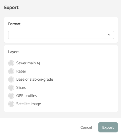
The layers visible on the export dialog box depend on the layers included in your specific project. Pulling down the Format menu reveals the possible export formats available, which will depend on the types of data available for export.
Export formats
CSV
These are ASCII text files used by many types of software to exchange data. For regional variations in the interpretation of CSV files, Geolitix provides you with options of using the comma "," or period "." as the decimal separator, and the "comma" or TAB character as the data delimiter. The types of layers which can be exported to CSV files are:
Depth grids
Amplitude grids
Polylines
Points interpretations
Horizon  interpretations
DXF
Drawing eXchange Format files are universal files for transferring vector models between software. DXF files contain 3D information for display and refinement in CAD software. The types of layers which can be exported to DXF files are:
Depth grids (output is a 3D mesh surface)
Polylines*
Points interpretations* (output is 3D aware)
Horizon interpretations* (output is 3D aware)
GPR Profiles (output is GPR tracks)
Isosurfaces (output is 3D mesh)
Sketches
*Exporting Polylines, Point interpretations and horizon interpretations as DXF models reveals a further dialog box.
In some instances, it is useful to export text boxes beside each node to show the depth of that point. Geolitix allows DXF exports to include these text boxes and provides you with options for a label prefix (e.g. "depth=") and/or suffix (e.g. " mm"). It is also possible to rotate the exported text boxes to align with the path of a Polyline.
GRD
These files are used in Golden Software's Surfer program for displaying gridded 2D datasets. The Surfer binary GRD format is also used in other GIS software to exchange x,y,z gridded data while maintaining data bit depth rather than simply pre-rendered image files. Exporting GRD files allows Geolitix output to be integrated into other mapping software. The types of layers which can be exported to GRD files are:
Depth grids
Amplitude grids
Slices
Thickness grids
KMZ
KMZ files are used by Google Maps and Google Earth to map geo-referenced vector features. Exporting elements of a Geolitix project to KMZ format allows external viewers to comprehend findings with geographical reference. NOTE that KMZ files can only be exported from geo-referenced projects. The types of layers which can be exported to KMZ files are:
Depth grids (a {color|colour} legend will be attached to the file)
Polylines
Point interpretations
Slices
GPR Profiles (output is GPS tracks)
PNG.
PNG graphic files are image files which can contain an alpha channel, enabling transparent pixels. This can be useful when exporting certain non-rectangular layers such as slices, as it enables these layers to be overlain atop other maps in GIS software with the original outline of the slice or depth grid maintained. For geo-referenced projects, PNG exports come with a PGW World file, which provides coordinate information for direct import into any GIS or mapping software. The types of layers which can be exported to PNG files are:
Depth grids (a {color|colour} legend will be attached to the file)
Amplitude grids (a {color|colour} legend will be attached to the file)
Thickness grids (a {color|colour} legend will be attached to the file)
Slices
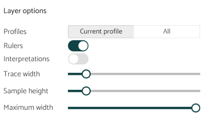
GPR Profiles*
- Exporting GPR profiles to PNG images reveals a further option box:
The user can select between exporting all profiles in the project as PNG files (which can result in a very large zipped file of all profiles) or only the current profile being displayed. Options for including the rulers (x and y axes) and interpretations (points and horizons) are provided. In addition, the trace width and sample height of each pixel can be controlled, which dictates the width and height of the output images. Finally, the maximum width of each output image can be limited for very long profiles.
ReflexW
Geolitix can export *.00T and *.00R files for use in Sandmeier Software’s ReflexW program as processed GPR files. These files must be placed in a REFLEXW PROCDATA directory to be properly viewed. Only GPR profiles can be exported as REFLEXW files.
SEGY
SEGY files are used to transfer seismic, sonar, and GPR datasets between geophysical software packages. There are various versions of SEGY files with no industry standard, and the original SEGY standard did not include allowance for time sampling in nanoseconds rather than microseconds. Geolitix uses the most common GPR SEGY format for export. Only GPR profiles can be exported as SEGY files.
Shapefile
Shapefiles are a popular geospatial vector data format developed by ESRI. They are widely used in GIS software and other mapping applications. Shapefiles store both geometric and attribute data for geographic features, making them versatile for representing and analyzing spatial information. Geolitix does not export a PRJ projection file with Shapefiles. The types of layers which can be exported as Shapefiles are:
Polylines
Points
Horizon interpretations